


Walking Around in San Francisco – the best way to visit it
Walking around San Francisco
Is San Francisco walkable?
What is the best way to visit San Francisco?
What are the best things to do and see in San Francisco?
When is the best time of year to visit San Francisco?
What are the highlights of San Francisco?
Discover the real San Francisco by walking around in it
Even though San Francisco is famous for its hills and steep streets, it is a very walkable city for tourists. San Francisco is rated the second most walkable city in the US. This is because most of the San Francisco’s highlights are clustered in a relatively small part of what is relatively small-sized city. I love when I explain to visitors that they can walk most of the city without climbing more than a small incline.
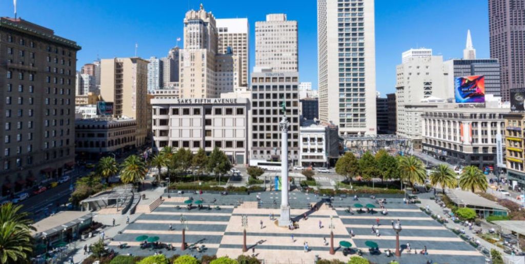
Union Square – San Francisco
San Francisco is one of those cities that you really need to ‘feel’ to truly enjoy visiting it. You need to be on a cable car as it spins a corner in a neighborhood. You need to stand in Union Square ‘feeling all the grand stores that surround it. Yes, most people you will see on this walk work in San Francisco, but mixed in are the characters who make San Francisco unique. Not everyone is a fashion designer or tech nerd. The crowd often includes the stately gentleman who looks like an ad from the 1950’s, the overdressed woman holding her poodle, and the 20 to 25-year-old girls whose shorts could use a couple more inches of fabric.
The murals, the crazy sculptures, the ancient street cars imported from around the world (and in full usage – F Line), the skyscrapers next to the 150-year-old two story buildings… these all get added to the variety in people. When I walk around San Francisco, I always love the new sights around every corner.
Add; the views of the bridges and the bay, the sailboats and huge freighters from all over Asia, the views of the hills and the views from the hills and you are starting to get a feel of San Francisco. Feel like China in Chinatown and turn the corner you are at the Four Seasons Hotel, or better still turn into Jack Kerouac Alley, Free Speech Corner and City Lights Bookstore (and their free speech Supreme Court Case.)
You will get all this and more on this walking tour of San Francisco.
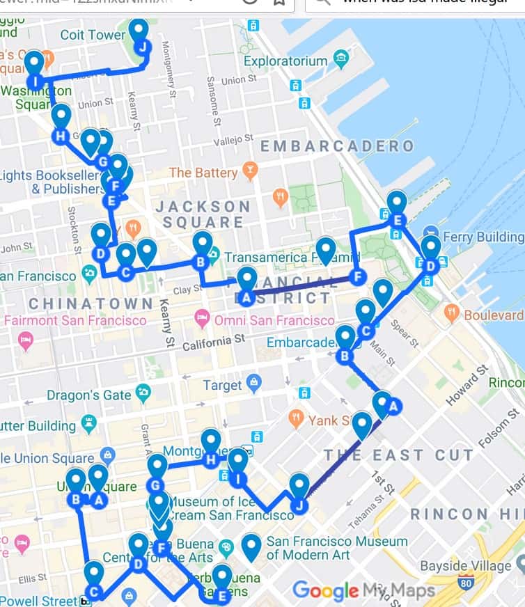
See detailed Interactive Printable Map of this walk on Google
The San Francisco Walk
Time/Length – Four to five hours – 4.8 miles (7.7 km) walk can easily be broken up with a food break at almost any time
What to do and see in San Francisco – Highlights on this walk
• Union Square Plaza, chic shopping, St Francis Hotel
• Powell Street Cable Car and turn around
• Market Street – Street Cars
• Yerba Buena Gardens – Moscone Center
• San Francisco Museum of Modern Art
• Museum of Ice Cream (Jewish Museum, Mexican Museum, African Museum are all nearby)
• SOMA _ South of Market
• Salesforce Tower and Millennium Tower
• California Ave Cable Car
• The Ferry Building
• Embarcadero
• TransAmerica Pyramid
• Chinatown
• Coit Tower
• North Beach – Little Italy
This walk gives you many things to see, but it will also allow to ‘feel’ San Francisco as you stroll through it. It will leave you with lots of ideas of things to do in San Francisco.
Seeing Union Square
I like starting at the center of Union Square, which is somewhat the ‘center’ of San Francisco. Not geographically, as Union Square is in the northeast corner of the whole city. But it is more the center of how San Francisco life spreads out. Two blocks to the south is the theater district, go another mile and you get to the Civic Center. The immediate north and east directions are the main shopping areas of San Francisco. The Westin St Francis, Hyatt, Hilton and other hotels are either on Union Square or within a block or two. Chinatown is three blocks to the west with North Beach, and Fisherman’s Wharf just a few blocks further. (If you want a bigger version of the downtown section of this walk try The Downtown Walk Union Square to the Ferry Building)
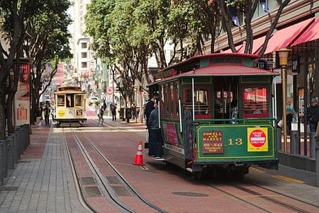
Powell Street Cable Cars
After enjoying Union Square and maybe taking a peek into the St Francis Hotel lobby to see if it is decorated for any of the holidays, I like to head down Powell Street (the one with the cable cars on it) to Market Street. I like to go down to where the Cable Cars are turned around — they used to let people help spin cable cars around and then jump on as they were spinning, but for safety this was discontinued. HINT: If you just want a Cable Car ride, it is often better to wait for them to stop at the Union Square corner. Then hop on there. The line to get on the cable cars at Market Street can sometimes be very long, especially during tourist times.
Lobby St. Francis Hotel
Market Street
Market Street was laid out at the same time as San Francisco (and all of California) was being transferred from Mexico to the United States in 1848 (at the end of the Mexican-American war). It was designed to be the widest street in the whole city at 120 feet (36 meters). And within 10 years of building the street, there was already a company using it for a horse drawn streetcar system on rails. Today there are still streetcars on rails (now electric) running the length of Market Street.
When you get to Market Street, look south and you can see that Market Street heads into a large hill and another major street, Van Ness Avenue. There are a mix of stores and offices along most of Market Street. Twitter, Uber, Square and many other smaller companies have their headquarters on that section of Market Street. Looking North, you will see the Ferry Building is at the end. And, of course, right behind the Ferry Building is San Francisco Bay.
Our walk goes north on Market Street for a block then turns east. Market Street now has wide sidewalks, I like to imagine it 100 years ago. Back then there were four sets of rails in the street as two different companies competed for streetcar customers and each had their own pair of rails. Market Street was actually busier back then few people had private automobiles and use of market Street’s public transportation was crucial.
South of Market, SOMA
For 100 years, the south side (really the southeast side) of Market Street (called SOMA by locals) was the ‘second’ side of the commercial center of San Francisco. Then, starting with the convention center, Moscone Center, in 1981, SOMA slowly, but steadily became the largest development area of the city. For the last 40 years there has been relentless expansion and modernization. Mission Street has been added to California Street and Montgomery Street as the location for new skyscrapers. This has spread southeast from Market Street to the Bay (where Oracle Park sits now). And has continued south past China Basin to where the new Chase Center and UCSF Medical Center are.
Yerba Buena Gardens
After turning south on Fourth Street, we go just one block to Mission Street and we arrive at the Metreon and Yerba Buena Gardens. The gardens (behind the Metreon Building) are a peaceful park in the midst of great commercial activity. The Metreon has an excellent main level food court and on sunny days, I like to get something from one of them and go sit in the park and enjoy it.

Yerba Buena Gardens and San Francisco Museum of Modern Art
Surrounding the park are; the Moscone Center – a huge complex of buildings that hold most of the larger conventions in San Francisco, San Francisco Museum of Modern Art – with a very cool looking building, The Arts Center, and The Contemporary Jewish Museum. On their own, these are all worth visiting if you have the time.
Our walk heads west through a nice pedestrian walkway back to Market Street. There are restaurants lining the walkway which are always busy for lunch (please note – there is always an endless availability of food on the streets of San Francisco). Again, you can get a ‘feel’ of San Francisco by watching the people as they interact, wait in line for a table or just sit on the benches to have a snack or check email. It is a productive atmosphere in the section of San Francisco, it has that busy New York City feel.
Also, on one side of the walkway, is the Four Seasons Hotel and on the other side is Marriott Marquis. Once you are out on Market Street, we cross it again and continue west on Grant Avenue. Right on the corner is one of the oldest Wells Fargo Bank Buildings and on the other corner is one of the many ‘flatiron’ buildings in San Francisco. Flatiron buildings are triangle shaped buildings with a very narrow angle at one end.
Museum of Ice Cream
San Francisco Ice Cream Museum
And just beyond the flatiron building is another old bank building which is now the Museum of Ice Cream (you might need advanced reservations to get in). The museum is interactive with ice cream and candy themed exhibits.
Maiden Lane
One block further down Grant Avenue, we stop at Maiden Lane. Prior to the 1906 earthquake this was one of the red-light districts of San Francisco full of brothels and bars. The earthquake and fire destroyed all of the building and ever since it was rebuilt it has been full of upscale stores and was closed to cars most of the time. Enjoy some expensive window shopping as we walk down Maiden Lane.
Bank of America and Wells Fargo Bank
When we reach Kearney Street, we are at the edge of San Francisco’s Financial District. Two of America’s biggest banks. Bank of America and Wells Fargo Bank, were started in San Francisco. Bank of America was started in 1904 (named Bank of Italy until 1928) In 1969, the Bank of America built the largest building in San Francisco located at the corner of Kearney and California streets. Wells Fargo Bank was founded in San Francisco in 1852. It offered banking services (which it continues to do today) and express transport (the famous overland stagecoach services).
We take Kearney ½ block west to Post Street and then head down Post Street to Montgomery Street. Some of the buildings we pass are modern skyscrapers and some date back 80 to 100 years ago when they were very tallest at the time. On one corner is One Montgomery which currently houses Wikipedia’s headquarters.
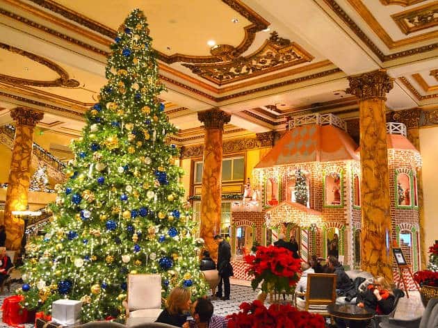
Palace Hotel
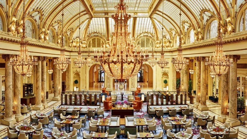
Great Hall – Palace Hotel
We head east on Montgomery crossing Market Street once again and continue east. We are in front of San Francisco’s Palace Hotel. I always take the time to go inside and see the Palace’s old-world lobby and great room. I find them spectacular and take you back to a time when this was the way grand hotels were built. The original Palace Hotel opened in 1875 and burned to the ground in 1906. This Palace Hotel was opened in 1909.
Mission Street
We continue walking toward Mission Street and go north. Mission Street was named for Mission Dolores which the street once ran past, before it was rerouted to its current location. Back then, it was part of the old El Camino Real, the original road that connected all of the missions in California in the 1700’s. Today, this section of Mission Street is the center of the tallest new buildings in San Francisco.
Salesforce Park
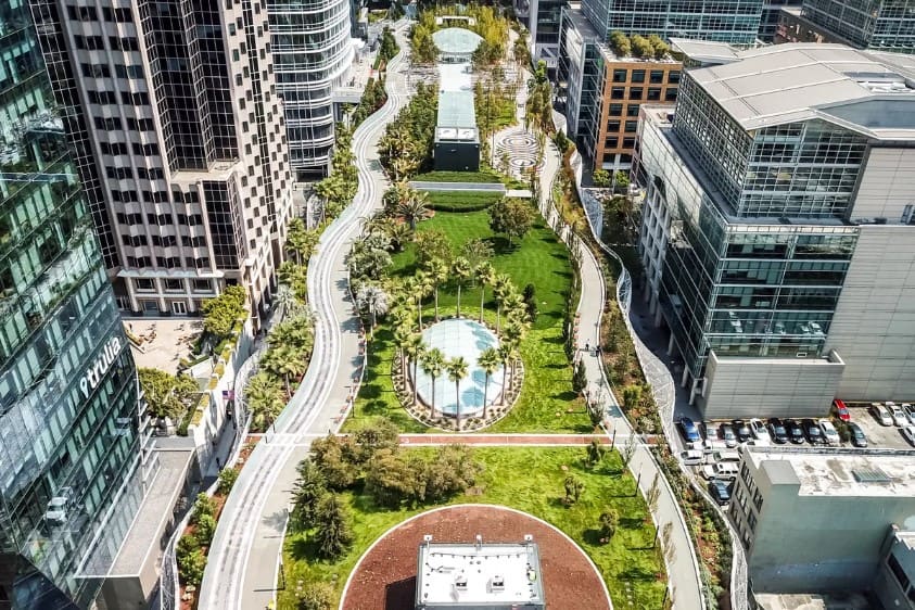
Salesforce Park
Go north on Mission Street for a block then east on Second Street to an alley called Minna Street. Here is one of the entrances to Salesforce Park, which is one of the newest additions to San Francisco. This is a 5-acre park, four stories above street level. The city’s transit center was rebuilt underneath the park as part of the development of all the land the previous transit center occupied. The park first opened in 2018 and at the north end, you can ride an aerial tramway down to Mission Street (or take the stairs or escalators).
Salesforce Tower and Millennium Tower
As you experience this ‘park in the sky’ with full grown trees, you will walk past Salesforce Tower. It is now the tallest building in San Francisco and headquarters of Salesforce. Public entry to the top is once a month on Saturdays, but you will need reservations through salesforce tower tours. As you walk the park, will also pass the Millennium Tower (58 stories high), which became famous for sinking (17 inches – 43 cm) and more dangerously leaning (14 inches – 36 cm) in just 9 years. There is a $100 million building permit granted to ‘fix’ it.

At the other end of the park we head down to street level. The corner of Mission and Main Street we head west one block toward Market Street. There we find the Embarcadero BART station. This is the first station in San Francisco after a train has gone under the San Francisco Bay waters – 4 miles (6.4 km) underwater. The station is often a very busy. Across the street is the Hyatt Regency Hotel, famous as one of the first hotels with hollow covered lobby – used in movie The Towering Inferno and High Anxiety.
California Street
This is also one end point of the California Street Cable Car Line. It was one of San Francisco’s first cable car lines, started Leland Stanford (later California Governor and founder of Stanford University). Take time to look at California Street as it climbs Nob Hill. Stanford build the cable car line to go directly past his family’s mansion one block before the top of Nob Hill. It burned to the ground in 1906 and it is now the location of the Stanford Court Hotel.
The Ferry Building

San Francisco Ferry Building and plaza
At this point, we only have to cross the park and the Embarcadero to the San Francisco Ferry Building which was built in 1898. Because of its reinforced arch construction and waterfront location, it survived the 1906 earthquake and fire. When cable cars dominated San Francisco, there were 23 cable car systems in Sam Francisco. Thirteen of them had one end point within walking distance of the Ferry Building. This building was the hub of Bay Area transportation for almost 40 years until the opening of both the Bay Bridge and the Golden Gate Bridge in the 1930’s.
If you are hungry, this is a great place to stop. There are several well-regarded restaurants in the Ferry Building, Gott’s for burgers and The Slanted Door for more upscale food and a view of the bay. Even if you are not hungry go through the Ferry Building to the back. The view of San Francisco Bay and the Bay Bridge are stunning.
Embarcadero Center

Embarcadero Center at night
Leaving the Ferry Building go north along the Embarcadero roadway. Visitors always notice how almost all of San Francisco’s Pier Buildings are identical in architectural style, a pleasant sight for most people. Our walking tour crosses over the Embarcadero at Washington Street to head back into the city from the bay shore. The four large identical office towers are the Embarcadero Center built in the 1970’s. They, along with the Bank of America and TransAmerica buildings, were the main rejuvenation projects of the Financial District. The Embarcadero Center has a combination of shopping malls, hotels and offices. The buildings still make a stunning sight at night.
Walk over to the first building and take on of the escalators up to the park level. Head west through all the shops and gardens. Take the walkways over the streets. Head back down at the end which is Battery Street. Walk one more block in the ground level pedestrian walkway to Sansome. On you r left you will be next to the stately Old San Francisco Federal Reserve Building. Turn right and go to Clay Street. Clay Street was the street on which the cable car was invented and first built.
TransAmerica Pyramid
Go up Clay Street and we come to the TransAmerica Pyramid building. Go to the corner of Washington Street and Montgomery Street, which is one of the corners of the TransAmerica Pyramid. It was here in July of 1846 that the captain of the gunboat USS Portsmouth, Captain Montgomery, rowed ashore to this very spot and walked up the hill one block to the square (which was then the center of the Spanish-Mexican village of Yerba Buena – soon to be changed to San Francisco).
There, he planted the American flag and San Francisco was declared US territory. You will note that corner you are standing on is now more than a half mile (.77km) from the water. All the land was filled in, mainly in the next 20 years during the California Gold Rush.
Visiting Chinatown

Chinatown – Grant Avenue
From the TransAmerica Pyramid, we go up one more block to Portsmouth Square. It is now one of the main parks in Chinatown and you can see many Chinese people (mainly men) playing (and gambling) on games like Mahjong and Go. You will suddenly feel like you are in China. As you walk up to Grant Ave, (the main tourist street of San Francisco Chinatown), you we see the Old Chinese Telephone Exchange. Because most San Francisco Chinese residents could not speak English, they set up their own telephone system back when you needed operators to connect calls and this was the building all the operators were in.
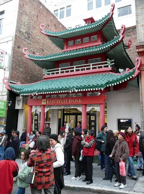
After reaching Grant Avenue, follow it west for a couple of blocks. Despite the fact that tourists have ‘invaded’ this street, most of the time ethnic Chinese people still are in a majority (if you go up the hill one block to Stockton Street it will be 90% Chinese people on the sidewalks.) There are plenty of Chinese bakeries and grocery stores to look into.
Fortune Cookie Factory
(There is a cool detour on this if you have time. On Washington Street keep going up the hill until you reach and alley named Ross Street. Turn into it and halfway down the alley is the Golden Gate Fortune Cookie Factory. Fun visit, then head back down to Grant Avenue.)
After walking two blocks, you will come upon a small alley on the north side of Grant Avenue. It is Jack Kerouac Alley, named after the author of On the Road and several other books. It is a short alley and the other end is Columbus Avenue which connects Fisherman’s Wharf to Downtown. It is an amazing feeling to go through an alley for 100 feet (30 meters) and leave China and arrive back in the US.
City Lights Bookstore
At the end of the alley are two buildings. On the right is Vesuvio Cafe (and bar). This was a main hang out for what was called The Beat generation, Beatniks, (this was mainly in the 50’s before hippies arrived.) Jack Kerouac, Allen Ginsberg, and Lawrence Ferlinghetti were frequent guests, the latter two are famous for the California Supreme Court Free Speech victory on Ginsburg’s poem Howl which Ferlinghetti published in the building next door – which is the City Lights Bookstore.
It may be small, but City Lights Bookstore is always in the top ten most famous bookstores in the world (along with Shakespeare and Co in Paris.) It claims to be the first all paperback bookstore, which in 1953 when almost all quality books were hardback was edgy. More edgy was what it published, ending with the aforementioned Supreme Court victory.
The Condor

The Condor – Carol Doda sign – 1973
On the Columbus Ave, Broadway Ave corner is The Condor. The Condor became San Francisco’s most famous topless bar/club. And Carol Doda its most famous dancer. The old photo here shows the condor as it looked in 1973 – the blond woman in the skimpy bikini was Carol Doda (the sign is still there and the club is now one only a couple topless dance clubs in San Francisco. Almost 50 years later, The Condor and Big Al’s next door look pretty much the same.
North Beach
Our walk continues north on Grant Avenue, past The Condor, and into the area known as North Beach. At the far end of the district there was a big sandy beach. In the late 1800’s it was filled in and the city was expanded about ⅓ of a mile (.5 km) into the Bay. North Beach was the area that was mainly settled by Italian immigrants and is sometimes known as Little Italy. It still has a good number of Italian restaurants, bakeries and delis.
The Godfather
As we head up Grant Avenue, we quickly pass a hole in the wall bar named The Saloon. It’s claim to fame is ‘the old bar in San Francisco’ and opened in 1861. Up on the corner of Grant Avenue and Vallejo Street is the Caffe Trieste. Francis Ford Coppola wrote most of the screenplay for The Godfather movie while sitting in this cafe.
We go down Vallejo Street back to Columbus Avenue and on the corner is a wonderful old Catholic church now named National Shrine of St. Francis of Assisi. Across Columbus is Molinari’s Delicatessen. It is certainly the most famous Italian Deli in San Francisco. I personally love their pastrami sandwiches.
As you head north on Columbus, you will pass a number of Italian restaurants with sidewalk tables, I have eaten at most of them at some time, and they all get a thumbs up if you are hungry.
Green Street
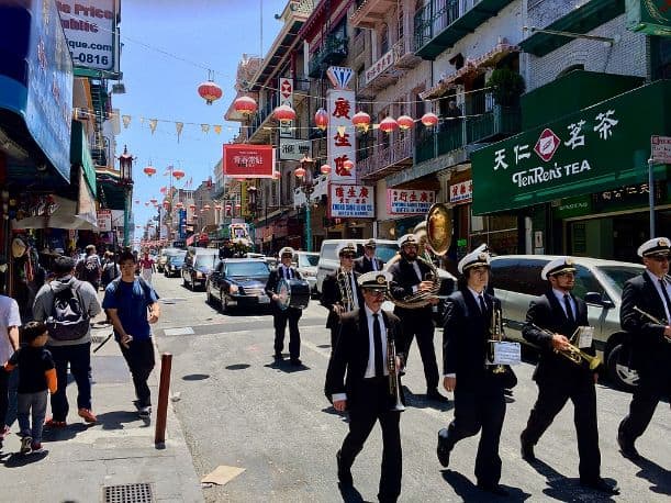
Green Street Mortuary funeral parade and band
After crossing Green Street, you can look west to see the Green Street Mortuary. They are famous for their funeral band and parades. They do a big business in Chinese funerals. One tradition being that you parade the casket to all the places the deceased often frequented. The parade usually includes a march down Grant Avenue. Across the street from the Green Street mortuary is Beach Blanket Babylon. A crazy live music revue with characters wearing crazy headpieces.
Washington Square
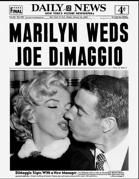
Heading north on Stockton Street we get to Washington Square. While this is definitely a local’s park, it has great tourist value. The stunning church, Saint Peter and Paul Church, was the location of the wedding photos for America’s most famous marriage in the 1950’s Marilyn Monroe and Joe DiMaggio. This was Joe’s home church since childhood, but the wedding was actually held at City Hall and just the photos were here. The church refused to wed them since Joe had been married and divorced before.
Mama’s restaurant on Washington Square almost always has a line, so if you get there and it is too long to wait, then go across the street to Liguria bakery, for San Francisco’s best focaccia. Be aware, they can sell out as well. As for pizza, Tony’s Pizza Napoletana is hard to beat. Again, they only make a certain number of each pizza (fresh ingredients), so you may not get your first choice.

Telegraph Hill wild parrots circling Washington Square
Washington Square is also ‘famous’ for its flock of wild parrots. They live all over Telegraph Hill and often can be seen or heard in Washington Square.
Telegraph Hill and Coit Tower
We saved Telegraph Hill and Coit Tower for last. You can skip it if you are too tired to climb up. But if you do, you will be rewarded with some of the best views of San Francisco. Lillie Coit added the tower as a gift to San Francisco in honor of its fireman.
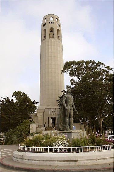
Coit Tower on Telegraph Hill
Prior to that the hill had been famous for its telegraph system. From the top of the hill, you can see out the Golden Gate into the Pacific Ocean. With a telescope you can easily see what ships are starting to come in. Sailing ships would take a long time before they would actually come through the gate and across the bay and finally dock at the port of San Francisco, And the hills blocked the view from the port until the ships were almost docked. So, the city erected a house on the top somewhat like a windmill. Then, using poles arranged differently they could signal, ‘telegraph’, to downtown San Francisco what ships were coming and the appropriate owner could get ready to meet it and unload it when it made port. Much to people’s surprise, once the electric telegraph was invented and put to use, the hill was no longer needed, as telegraph messages from Monterrey and other places on California’s cost kept people in San Francisco well informed.
In any case, time to find one of those North Beach Italian restaurants to rest your legs and have a glass of wine – you earned it.
Planning a trip to Paris ? Get ready !
These are Amazon’s best-selling travel products that you may need for coming to Paris.
Bookstore
- The best travel book : Rick Steves – Paris 2023 – Learn more here
- Fodor’s Paris 2024 – Learn more here
Travel Gear
- Venture Pal Lightweight Backpack – Learn more here
- Samsonite Winfield 2 28″ Luggage – Learn more here
- Swig Savvy’s Stainless Steel Insulated Water Bottle – Learn more here
Check Amazon’s best-seller list for the most popular travel accessories. We sometimes read this list just to find out what new travel products people are buying.