


Top 10 Remarkable Facts about Pontcysyllte Aqueduct
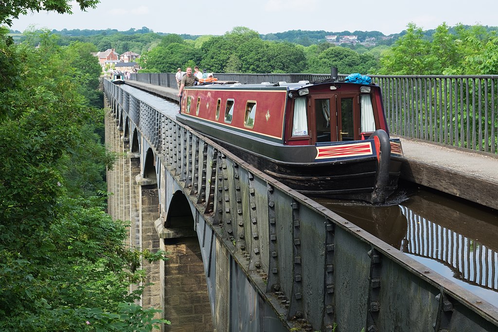
Pontcysyllte Aqueduct by DeFacto from Wikimedia Commons
It’s difficult to believe that a building project that was started in the year 1795 is still in use and a well-liked tourist destination in the twenty-first century, but that is exactly the case with this amazing structure.
The Pontcysyllte Aqueduct is one of Wales’ most incredible structures, and in this article, we’ll examine some of its most fascinating details.
1. It is a portion of a canal that connects Wales and England

Pontcysyllte Aqueduct by DronePics.Wales from Wikimedia Commons
In the northeastern region of Wales, there lies a magnificent technical feat is known as the Pontcysyllte Aqueduct. The Llangollen Canal, which spans the River Dee, includes it. In the far northeastern region of the nation, in the Wrexham County Borough, close to the community of Froncysyllte, is where the aqueduct is situated.
The River Dee runs close to the boundary between England and Wales, and portions of it serve as that border. The border is also only a few kilometres distant from the aqueduct.
2. This magnificent building was finished in 1805
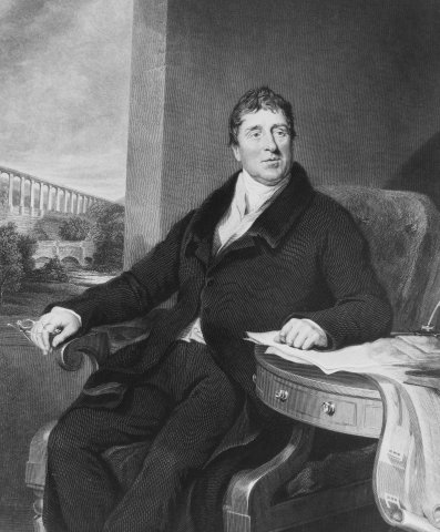
ThomasTelford by Dumelow from Wikimedia Commons
Construction on this specific aqueduct began as part of a much bigger project back in 1795, which is what makes it so intriguing. The “Pont Cysyllte,” a road bridge from the 17th century, is not more than 200 meters (656 feet) east of where the aqueduct was finally constructed.
There is Thomas Telford, a Scotsman, who was the project’s principal civil engineer and became one of the most well-known British engineers of the 19th century (1757-1834). Despite the fact that Telford had assistance from the considerably more skilled English engineer William Jessop (1745–1814), Telford is regarded as the project’s principal engineer, as can be seen on a plaque nearby that marks the project’s completion. Just over ten years after work began, on November 26, 1805, the spectacular aqueduct finally allowed boat navigation.
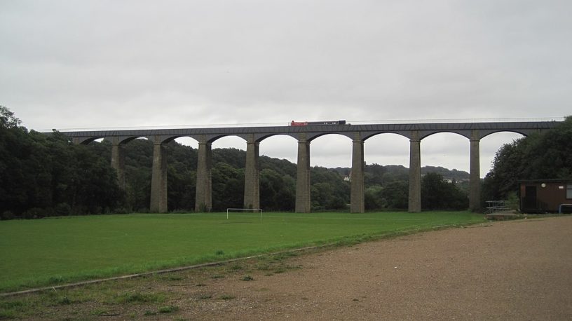
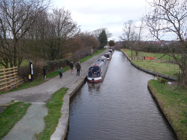
3. It has some outstanding statistics for a structure that is over 200 years old
Traphont Pontcysyllte by Llywelyn2000 from Wikimedia Commons
Of course, the Romans were able to construct aqueducts that were much more amazing and could provide water to whole towns. The “Pont du Gard,” one of the most remarkable instances of their technical prowess, is located in Southern France. This does not imply, however, that the aqueduct in northeastern Wales is any less remarkable; on the contrary, it boasts some very remarkable statistics:
- Length: 307 meters (1,007 feet)
- Width: 3.7 meters (12 feet)
- Height: 38 meters (126 feet)
- Water depth: 1.6 meters (5 feet 3 inches)
The bridge is made up of 18 arches as well as 4 piers that are submerged in the river below. It’s also considerably longer than it first looks to be. It holds the world record for being the tallest navigable canal and the longest aqueduct, both of which are astounding records for a construction that was built more than 200 years ago.
4. The aqueduct’s planned use was never truly fulfilled
The canal in Ellesmere by Jeremy Bolwell from Wikimedia Commons
The Ellesmere Canal across the River Dee was the name of the bigger project, of which the aqueduct was a crucial component. This canal was intended to link the Mersey and Severn rivers in Wales and England. This would have established a link between the Port of Liverpool in the north and the developing mining sector in Wales’ northeast. The complete concept was never fully implemented due to a lack of funds.
Even more amazing is the fact that this extensive plan’s first and last projects were the Pontcysyllte Aqueduct. The canal’s northern terminus ultimately became the Trevor Basin, which is just to the north of the building and far from Liverpool’s Port. The construction of several canals and aqueducts in the region finally ensured that the aqueduct suited the needs of the regional economy.
5. Even now, the aqueduct remains a well-liked tourist destination
Although the local industry first used the aqueduct heavily, this subsequently decreased as railways were built to replace the canals. There were also intentions to turn the canals into railways halfway through the 19th century, but this idea was ultimately abandoned. Otherwise, instead of a passable canal today, we would have been staring at a railway.
The amount of traffic on the canal had drastically decreased by the 1930s, and as a result, the aqueduct was formally closed to commercial traffic in 1944. This indicates that when recreational boats began using the canal more often in the second half of the 20th century, the aqueduct’s intended usage underwent a complete shift. It was at this point that the incredible aqueduct period began.
6. What does Pontcysyllte mean?
Pontcysyllte Aqueduct by Mike Prince from Wikimedia Commons
The aqueduct’s name is a reference to the name of the town where it is situated. The Welsh name “Pontcysyllte” refers to the historic township section of the hamlet of Llangollen and means “Cysyllte Bridge” or “Bridge of Cysyllte.”
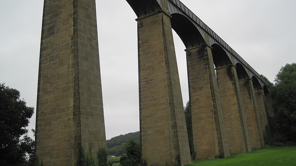
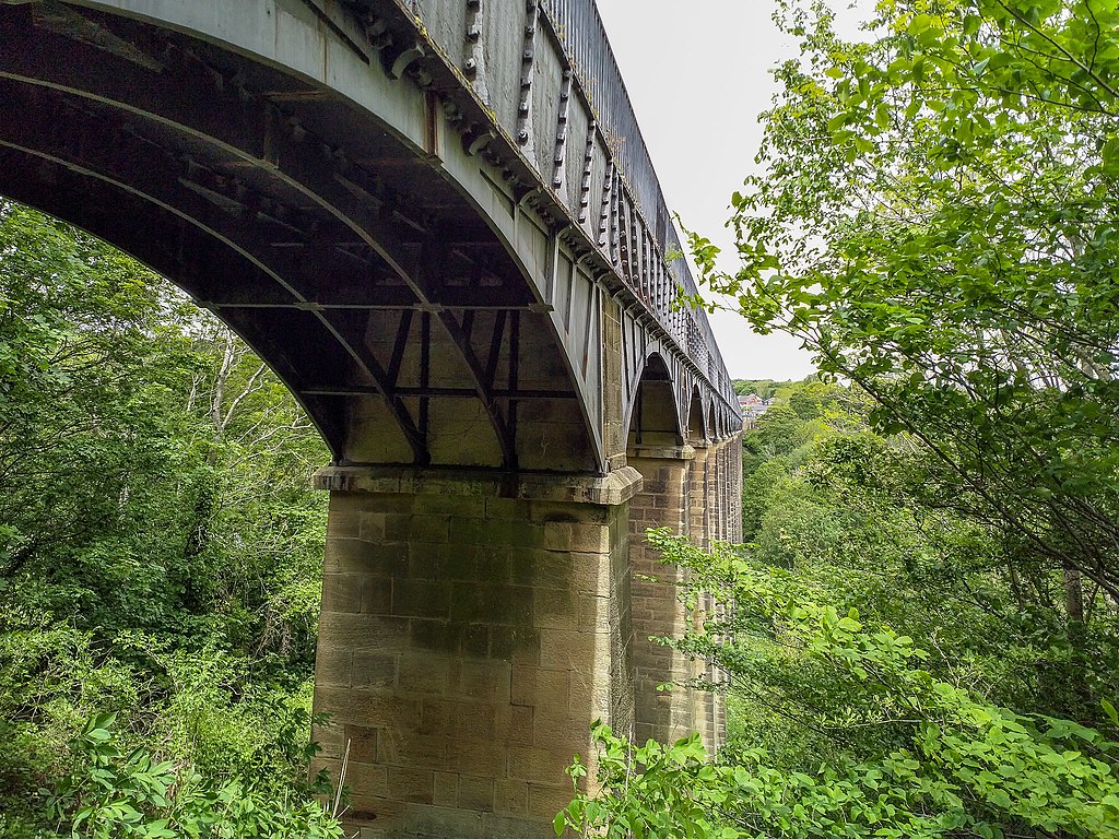
7. The structure of the aqueduct
The cement used to construct the bridge was fortified with a specific animal product to strengthen the structure and safeguard it from the chilly winter weather conditions.
Large chunks of sandstone are held together by a mortar that was created using a mixture of lime, water, and ox blood. This was an affordable way to reinforce the building and a combination that had been employed in antiquity.
8. The building materials that were used
The aqueduct was constructed using a mix of cast iron and stone elements. The neighbouring community of Cefn Mawr is where the sandstone was mined.
Locally known as “The Rock,” this quarry produced sandstone with a high quartz content. The “Rock Stadium,” also known as the football stadium for the neighbourhood football team “Cefn Druids,” was where these stones were found.
9. It was almost turned into a railway

Shropshire Union Canal by Roger Kidd from Wikimedia Commons
The canal inside the aqueduct was once again rescued during the 20th century after almost becoming a railroad track in the 19th. It nonetheless fulfilled two crucial functions despite the fact that it was closed to commercial traffic. One intended to supply water to the Shropshire Union Canal, another canal in the region. Additionally, it provides drinking water to a reservoir next to Hursleston.
When the Mid & South East Cheshire Water Board assumed control of the aqueduct in 1955, the canal’s survival was entirely assured.
10. It was a very expensive project
The aqueduct ended up being a highly expensive undertaking in the early 19th century, even though it never played a significant role in a fantastic river that extended all the way up to the Port of Liverpool.
During the ten-year building period, around £47,000 was invested, which is almost comparable to £3.9 million today! A link to Moss Valey, Wrexham, was supposed to be part of the project’s subsequent phase, however, it was never finished.
If height doesn’t concern you then we encourage you to walk across the aqueduct or save your legs and go by boat – remember to bring your camera and a head for heights!
Planning a trip to Paris ? Get ready !
These are Amazon’s best-selling travel products that you may need for coming to Paris.
Bookstore
- The best travel book : Rick Steves – Paris 2023 – Learn more here
- Fodor’s Paris 2024 – Learn more here
Travel Gear
- Venture Pal Lightweight Backpack – Learn more here
- Samsonite Winfield 2 28″ Luggage – Learn more here
- Swig Savvy’s Stainless Steel Insulated Water Bottle – Learn more here
Check Amazon’s best-seller list for the most popular travel accessories. We sometimes read this list just to find out what new travel products people are buying.


.jpg)